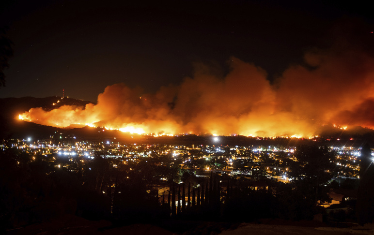
A fast-moving fire broke out on Halloween night in Ventura County exploded to more than 8,000 acres overnight, promping mandatory evacuation affecting at least 7,500 people. Many nearby school districts have cancelled classes due to this fire.
The Maria Fire is burning in a mountain area between Santa Paula and Somis, a ranching and farming community. The fight against the fire was hampered late Thursday when authorities grounded air support for the fire after a drone was discovered flying in the fire zone.
In better news, fire officials said they did not believe the Maria Fire would grow as large as 2017's Thomas FIre that burned for nearly 40 days and ate throughabout 282,000 acres — or 440 square miles.
Based on the Maria Fire's location, which started no a ridge, fire authorities said they believed the fire will run out of fuel at some point.
The Maria Fire started just after 6 p.m. on South Mountain and authorities warned that the fire was spreading rapidly. It was 0% contained as of early Friday.
About 250 firefighters were on scene, supported by three water-dropping helicopters and more than 30 engines, which were positioning to defend homes, according to the fire department.
Crews will continue to work amid dangerous weather conditions. A red flag warning was extended through 6 p.m. Friday, with winds expected up to 25 mph, with gusts of up to 35 mph, and single-digit humidity, according to the National Weather Service.
The cause of the fire is under investigation.
THE BASICS
- Acreage: 8,000 acres
- Containment: 100%
- Structures destroyed: N/A
- Structures threatened: N/A
- Resources deployed: 250 firefighters
EVACUATIONS
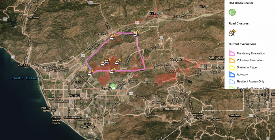
Mandatory:
- North Boundary : South Mountain Road
- West Boundary: West Los Angeles Ave
- East Boundary: Balcom County Road
- South Boundary: Highway 118
Road closures:
- South Mountain Road between 12th Street and Balcom Canyon
- Berylwood Rd. at Aggen Rd.
- West La Loma Rd. between Center Rd and Walnut Ave.
- Price Rd. at E. Los Angeles Ave (Hwy 118)
- Clubhouse Drive at E. Los Angeles Ave. (Hwy 118)
EVACUATION CENTER
For people:
- Camarillo Community Center: 1605 Burnley St., Camarillo
For animals:
- Camarillo Animal Shelter (Small Animals): 600 Aviation Dr, Camarillo
- Ventura County Fairgrounds (Large Animals): 10 W. Harbor Blvd., Ventura
- Earl Warren Showgrounds (Large Animals): 3400 Calle Real, Santa Barbara
Note:
#MariaFire; Has grown to 8,060 acres. The winds have subsided a bit and the cold temperatures have reduced the fires ability to aggressively run down hill. Ground and air resources are strategically attacking the perimeter. pic.twitter.com/LWRjZDxsZW
— VCFD PIO (@VCFD_PIO) November 1, 2019
This story will not be updated again until Friday morning. For the latest updates, follow the Ventura County Fire Department on Twitter and check vcemergency.com, where you can look up your address to see if you're in an evacuation zone.
SCHOOL CLOSURES
School Districts
- Briggs School District
- Hueneme Elementary School District
- Mesa Union School District
- Mupu School District
- Oxnard Union High School District
- Santa Clara Elementary School District
- Santa Paula Unified School District
- Ventura County Office of Education Schools [Exceptions: ACCESS, Ojai TEAMS, Providence School and Triggs School]
Charter Schools
- ACE (Camarillo)
- Univerity Preparation (Camarillo)
HOW WE'RE REPORTING ON THIS
Reporter Jacob Margolis is heading to the fire zone. KPCC news producers Emily Henderson and Briana Flores are reporting from the station. Ryan Fonseca is keeping this story updated.
ADDITIONAL INFORMATION
For the latest information straight from local emergency officials, check the following websites and social media accounts:
FIRE RESOURCES
- Every Day Is Fire Season. Here's How Angelenos Can Prepare Right Now
- How To Find Out About Fire Evacuations In Your Area
- How To Keep Yourself Safe From Wildfire Smoke
- The Air Is Brown — Should I Wear A Mask?
- This Is Why Fire Officials Don't Want You To Stay And Defend Your Home
- What Does 'Containment' Of A Fire Mean, Exactly?
- What Does A 'Red Flag Warning' Mean, Exactly?
- What To Do — And Not Do — When You Get Home After A Wildfire
- How To Avoid Getting Towed During LA's Red Flag Parking Restrictions
- If You Want To Help Fire Victims, Resist The Urge To Volunteer
YOUR QUESTIONS OR IDEAS