
A brush fire exploded in Ventura County Thursday night, quickly consuming more than 7,400 acres and burning structures.
The blaze, which has been dubbed the Maria fire, broke out atop South Mountain, just south of Santa Paula, and was moving toward the small agricultural towns of Somis and Saticoy. At least two stuctures have been lost, and 1,800 are threatened.
Authorities issued mandatory evacuations for a swath of homes bordered by South Mountain Road on the north, Highway 118 on the south, Los Angeles Avenue on the west and Balcom Canyon Road on the east. With night falling, firefighters were trying to box the fire in that area and keep the flames from spreading north toward Santa Paula and south toward Somis.
The evacuation orders encompassed about 7,500 people, the Fire Department said. The Camarillo Community Center was opened as an emergency shelter.
Aerial video footage showed at least one home burning along the southern flank of the fire, near La Loma Avenue and Center Road.
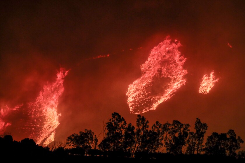
The Maria fire burns thousands of acres of hills stretching from Santa Paula to Somis in Ventura County.
(Robert Gauthier/Los Angeles Times)
About 400 firefighters were battling the fire, with helicopters dropping water on the blaze as engine crews on the ground tried to keep it from spreading toward homes.
Because the blaze broke out high on the ridge, it gave authorities time to conduct evacuations before the flames moved down the mountain and into residential areas, Ventura Fire Assistant Chief John McNeil said. But the remote location also made it difficult for fire trucks to access, he said.
“I want to assure you that this is not the Thomas fire,” he said, referring to the massive 2017 fire. McNeil said the location of the Maria fire means it will probably run out of fuel to burn once it reaches more manicured landscape at the bottom of the hill.
At one point, aerial firefighting efforts were hampered by a small drone that was being operated above the fire, apparently by someone looking to photograph the blaze, Ventura County Sheriff Bill Ayub said. Aerial operations had resumed by about 11 p.m.
By midnight, winds were still blowing the fire from the northeast to the southwest, with sensors recording winds at about 20 to 30 mph, said David Gomberg, meteorologist with the National Weather Service’s Oxnard office. A big problem was the persistently dry air — the relative humidity in the area of the fire was a bone-dry 5%.

The Maria fire burns thousands of acres of hills stretching from Santa Paula to Somis in Ventura County.
(Robert Gauthier/Los Angeles Times)
There was one silver lining — the fire broke out when winds were easing; had this area ignited just 24 hours earlier, “we’d be talking about 50 mph to 60 mph winds, and that’s a whole different ballpark,” Gomberg said.
The Times is offering fire coverage for free today. Please consider a subscription to support our journalism.
The Santa Ana winds from the northeast were expected to remain persistent through Friday morning and probably through midafternoon. At around 3 p.m., forecasters expect sea breezes from the Pacific Ocean to make their first appearance since Tuesday.
Ventura County is already dealing with the Easy fire, which started Wednesday and threatened the Ronald Reagan Presidential Library. That fire has burned 1,700 acres.
Santa Paula sits in the Santa Clara River Valley, among the most dangerous wind and fire corridors in Southern California. The river valley forms a wind-tunnel-like corridor, essentially connecting the high desert and the Santa Clarita Valley with the Oxnard Plain on the Ventura County coast between Oxnard and Ojai. The topography carries the potential for funneling severe Santa Ana winds.
Toward the eastern part of that corridor, the recent Saddleridge fire was the third blaze near Sylmar in 11 years. Previously, the Sayre fire burned 11,000 acres in November 2008, and the monthlong Creek fire burned 15,000 acres in December 2017. That same month, the huge Thomas fire, at the western end of the Santa Clara River Valley, burned 280,000 acres in Ventura and Santa Barbara counties.
The Maria fire broke out as crews continue to battle multiple fires across Southern California, including fires in San Bernardino and Jurupa Valley that together burned hundreds of acres and prompted thousands of residents to flee their homes.
Critical fire weather is expected to remain in place for the windiest areas of Ventura and L.A. counties through at least Friday afternoon, continuing red-flag conditions for an additional 24 hours. Unless it’s canceled early, that would make this period of critical fire weather that began on Tuesday at 11 p.m. at least 67 hours long. That’s an unusually long duration for such a red flag warning; most last one or two days.
The red-flag warning, which sounds the alarm for high winds, dry air and parched vegetation, is expected to persist for inland mountains in Los Angeles and Ventura counties, valleys in Ventura County and the Santa Clarita Valley through at least Friday evening because of ongoing winds from the northeast and very dry air.
There’s a possibility that critical fire weather could persist into Saturday.
Santa Ana winds are expected to get weaker each day, and Gomberg said forecasters expect fire risk to significantly diminish by Sunday. “As soon as we lose the wind by Sunday or Monday, we’ll definitely be in a better situation,” Gomberg said.
The cause of this strong Santa Ana wind event has been a particularly powerful mass of cold high-pressure air sitting over the Rocky Mountains and Great Basin over Nevada and Utah, causing record low temperatures for this time of year there.
That considerable temperature difference with the West Coast has set up a particularly big difference in air pressure, which sends fast and dry winds over mountains and through canyons toward the low-pressure voids on the California coast.
But with temperatures in the Rockies and Great Basin starting to increase, the weakening difference between air pressure inland and on the California coast is expected to allow the normal sea breeze from the Pacific Ocean to return to the Southern California coast starting Friday, Gomberg said.
Top wind gusts recorded Thursday were still strong — 67 mph in a Ventura County coastal valley, the National Weather Service reported, compared with a peak recorded Wednesday of 78 mph at Boney Peak in the Santa Monica Mountains. The air is still bone dry, with relative humidity levels in Simi Valley, the site of the fire that threatened the Reagan Library, at 8% Thursday.
Gusts of up to 54 mph were recorded close to the Cajon Pass, near where the Hillside fire in San Bernardino spread Thursday morning. At Riverside Municipal Airport, gusts of 25 mph to 30 mph were recorded near a fire in Jurupa Valley, said Jimmy Taeger, meteorologist with the National Weather Service office in San Diego.
Times staff writers Paul Duginski and Robert Gauthier contributed to this report.