A few inches of snow fell overnight across southern Minnesota, including in parts of the metro, but the bulk of the snow is yet to come.
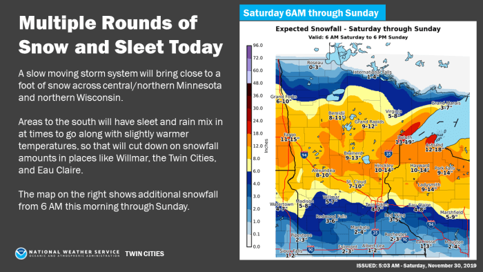
It could snow all day and night before winding down Sunday in central and northern Minnesota, while the Twin Cities is expected to deal with sleet, mixed precipitation and even some rain before transitioning back to snow later Saturday through Sunday.
"Areas north of Redwood Falls to the Twin Cities and Eau Claire have the best chance of seeing all snow, and have the higher snow amounts. Areas to the south will see a rain/snow/sleet mix at times and that will lead to lesser snow amounts," the National Weather Service said Saturday morning.
Overall, another 4-7 inches could fall in the south metro while anywhere from 5-10 could pile up in the northern suburbs. The bigger totals are still expected to fall in central and northern Minnesota, with the Duluth area along the North Shore getting hammered with up to two feet total by the time it's all said and done.
The changeover to all snow in parts of the Twin Cities that get sleet/mixed precipitation/rain should happen around 6 p.m., according to the weather service. But the longer it takes to transition, the lesser the snow totals will be.
For the Gopher football game against the Badgers at 2:30 p.m., it looks likely that the Twin Cities will still be experiencing a mix or all rain.
While the metro deals with different precipitation types and central and northern Minnesota are treated to heavy snow, the North Shore is going to get pounded. One to two feet of snow is expected to fall along with 45 mph winds possible.
Essentially, locations within 5-10 miles of Lake Superior can hunker down at home as blizzard conditions will be likely.
We'll update the story if the weather service provides any additional changes.


