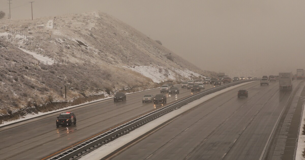
Interstate 5 through the Grapevine was closed Thursday morning amid heavy snow as a second powerful winter storm moved into Southern California on Thanksgiving Day.
Showers and possible thunderstorms were on tap for the Southland, with rain and snow continuing in Northern California.
The National Weather Service issued flood warnings and advisories for parts of Southern California for Thursday morning. Intense downpours of up to half an inch an hour threatened to cause road flooding and mudflows in recent wildfire burn areas, including the hillsides where the Getty fire burned a month ago in Brentwood.
Snow was falling in Lancaster and other parts of the Antelope Valley and mountain communities.
Interstate 5 through the Tejon Pass was closed around 4 a.m., with Caltrans urging motorists to use Highway 101 instead. Because the 101 is at a lower elevation, it generally doesn’t get enough snow to force a closure.
Travelers driving between the Bay Area and Los Angeles can take Highway 101 the entire way and avoid Interstate 5 completely.
Authorities were working to clear disabled vehicles and open the interstate.
We are still clearing stuck vehicles and the snow is still falling. We will provide an update when something changes. We do not have an estimated time of reopening. We will post and tweet when we do. SR-58 is open but we recommend US-101 as the preferred detour.#Grapevine pic.twitter.com/tapGutB8sg
— CHP Fort Tejon (@CHPFortTejon) November 28, 2019
“Priority will be to assist vehicles already on the pass to the other side, followed by clearing the roadway for continued use as soon as possible,” the California Highway Patrol said in a statement.
Up to 6 inches of snow was forecast for the pass. Snow levels were expected to plunge below 2,000 feet.
A flash flood warning was in effect for Orange County until 11:30 a.m. Thursday.
By 9:30 a.m., just over an inch of rain had already fallen in the Huntington Beach area, and half an inch to seven-tenths of an inch had fallen in San Clemente, the National Weather Service said.
Areas expected to experience flooding included Anaheim, Santa Ana, Irvine, Huntington Beach, Garden Grove, Orange, Fullerton, Costa Mesa, Mission Viejo and Tustin. The rain was forecast to continue all day, with isolated thunderstorms possible throughout the county, especially closer to the coast.
Wednesday’s downpours were not always long-lasting, but they could be intense. Record rainfall for the day was reported in a few spots including Santa Barbara Airport, Santa Maria and Lancaster, which had 0.43 inches.
As this storm fades by Friday, a new winter storm is expected to arrive in Northern and Central California on Saturday, persist through the busy Sunday travel day and continue through Tuesday.
It could hit Southern California by next Wednesday and Thursday.
But unlike the Thanksgiving week storms that have resulted from a cold front from the Gulf of Alaska, next week’s storm is expected to be fueled by an atmospheric river of subtropical moisture from the west — long plumes of water vapor that can pour over from the Pacific Ocean through California. As a result, there should be heavy precipitation, but it’s still too early to pinpoint exactly where rain and snow will be funneled.
“It’s kind of like a fire hose, which is hard to control,” said Carolina Walbrun, meteorologist with the National Weather Service’s Monterey office. “Right now, we’re confident that there’s going to be rain, and a lot of it, on Saturday afternoon through Sunday. Where the heaviest precipitation is going to be is still uncertain.”
Depending on what areas are affected by the atmospheric river, there could be concerns about mudslides for recently burned areas, such as the Kincade fire area of northern Sonoma County, which burned through very steep terrain.
“If that fire hose aims toward that burn scar,” Walbrun said, “we’re going to have some issues.”
Rich Thompson, meteorologist with the weather service’s Oxnard office, reiterated that, in Southern California, the atmospheric river could bring a good soaking to the L.A. area by Wednesday or Thursday.
This week’s storm has caused problems from San Diego to Oregon.
Motorists were stuck overnight on Interstate 5 between Redding and the Oregon border before the roadway was closed. They caught the brunt of the cold statewide storm system, which unleashed heavy rain, blustery winds and low-elevation mountain snow.
The cold front arrived in portions of Northern California on Tuesday, causing headaches for motorists. In San Francisco, which has been essentially dry for eight months, the storm brought about an inch of rain and pea-sized hail. Flooding bedeviled freeways throughout the Bay Area.
Powerful winds rocked northwestern California, with Crescent City in Del Norte County seeing gusts of 60 to 70 mph Tuesday, said Brad Charboneau, a meteorologist with the National Weather Service in Eureka.
A weather phenomenon known as a “bomb cyclone” — a low-pressure system that quickly strengthens — formed off the West Coast, bringing what is believed to be the lowest pressure ever recorded in California to Crescent City on Tuesday, Charboneau said. That low pressure drove the strong winds, he said.
Times staff writers Hailey Branson Potts, Anh Do, Paige St. John and Hannah Fry contributed to this report.
